Grass Strips by State

corcoran

Orbiting Earth
One of the local pilots from Mansfield, Massachusetts assembled this list of grass runways.
It is sort-able by state.
I see some omissions but many BAC members might find it useful.

In Massachsuetts I would add Myrics in Berkley, Tradewind on Martha's Vineyard, KTAN in Taunton, and others that I will eventually think of.
 

Attachments

Last edited:

Nice!!!!!!!!!!!!!!!!!

One of the local pilots from Mansfield, Massachusetts assembled this list of grass runways.
It is sort-able by state.
I see some omissions but many BAC members might find it useful.

In Massachsuetts I would add Myrics in Berkley, Tradewind on Martha's Vineyard, KTAN in Taunton, and others that I will eventually think of.
 
That a-hole is taking credit for my work? Who is it? That's my spreadsheet! I'll send it to your email.
 
Would you like one of every airport that allows camping? Some pilot in Mansfield is probably sharing that one too!
 
Taildragger strips

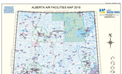
Here in Alberta, the provincial Alberta Aviation Council publishes a list of all landing spots in the province and updates every three to four years. New ones when printed are mailed out to members.

Per the png, the colour map of the province is about six feet high and there is a booklet that goes with it that details each strip.

The big deal is that it has all the taildragger forestry and farm strips as well.

https://www.albertaaviationcouncil.com/publications

Alberta Aviation Council 2018 Laminated Map.PNGAlberta Aviation Council 2018 Booklet.PNG
 
Guy's name is Steve Johnson. He did not claim authorship but did distribute it openly.

OK, that makes me feel better. I'm going to put a watermark on it so others can't take credit for it. I don't care who has it but I just don't want someone else taking credit for it!
 
Here in Alberta, the provincial Alberta Aviation Council publishes a list of all landing spots in the province and updates every three to four years. New ones when printed are mailed out to members.

Per the png, the colour map of the province is about six feet high and there is a booklet that goes with it that details each strip.

The big deal is that it has all the taildragger forestry and farm strips as well.

https://www.albertaaviationcouncil.com/publications

View attachment 13493View attachment 13494

Wow! That's great. I wish we had something like that!
 
Watermark location

OK, that makes me feel better. I'm going to put a watermark on it so others can't take credit for it. I don't care who has it but I just don't want someone else taking credit for it!
The Watermark is a good idea but might I suggest something more like a footnote - that is fine print running up and down the vertical margins left and right sides of the paper.

That way it can be legible but in no way obtrusive. You have put alot of work into the airstrip listing and I presume intend to update it on occasion. As such, a watermark that also includes revision dates is something that would be welcomed and referred to.
 
One of the local pilots from Mansfield, Massachusetts assembled this list of grass runways.
It is sort-able by state.
I see some omissions but many BAC members might find it useful.

In Massachsuetts I would add Myrics in Berkley, Tradewind on Martha's Vineyard, KTAN in Taunton, and others that I will eventually think of.

Myricks (1M8) is in the spreadsheet. KTAN is 1900' and didn't meet my minimums of 2000' and Tradewind is Private Use and this was public use airports only.
 
Tradewind is a funky grass airport on the popular island of Martha's Vineyard, Massachusetts.
It is pretty much open to anyone who gets permission. It is one of 3 airports on The Vineyard; KMVY, 1B1 Katama and Tradewind.

http://mvlandbank.com/Landing_at_Trade_Wind.shtml

In the old days you had to pass a landing-inquiry administered by Carolyn the airport manager. She wanted to see your logbook. If you only landed on long runways you didn't get to use Tradewind. 2,200' with tall trees at each end.

Thread drift: Today marks exactly 30 years of having a pilot certificate. Got it on July 7, 1990 one hour before my oldest son got his.

Tom Corcoran
 
Last edited:
I have my permission slip!

Tradewind is a funky grass airport on the popular island of Martha's Vineyard, Massachusetts.
It is pretty much open to anyone who gets permission. It is one of 3 airports on The Vineyard; KMVY, 1B1 Katama and Tradewind.

http://mvlandbank.com/Landing_at_Trade_Wind.shtml

In the old days you had to pass a landing-inquiry administered by Carolyn the airport manager. She wanted to see your logbook. If you only landed on long runways you didn't get to use Tradewind. 2,200' with tall trees at each end.

Thread drift: Today marks exactly 30 years of having a pilot certificate. Got it on July 7, 1990 one hour before my oldest son got his.

Tom Corcoran
 
Back
Top