Fly Over The Boston Marathon

corcoran

Orbiting Earth
April 18, 2016
See every runner (25,000+). See the entire race course (26.2 miles). Hold fixed wing altitude at 1250' msl. Keep your turns counterclockwise. Mix in with the banner tows, State Police and TV helicopters, military fly-over. Even the Secret Service is there including FAA people. If you can handle being inside this "cluster" you'll love the excitement.

Staggered starts from about 10am. Do the BAC lunch thing... Fly over the start and course. Land at KOWD and get in group car. Drive to halfway point (Wellesley). Arrive in time to see lead runners pass by and then watch tens of thousands more struggle along towards Boston. Sit in lawnchair. Eat sandwich. Take photos.

Get a stylish BEECH BUM T-shirt and a BAC Pilot Skills Certificate.

A BAC annual tradition. Call Tom Corcoran for info and local rules. 781 843-4321

 
WEATHER LOOKS GOOD

For FAA advisory info google: faa gov boston marathon start times pp. (Power Point)
This will give all the altitudes and frequencies and direction to fly.
Call Flight Service before you go on Monday morning. They may have correct info. Usually not!
We meet in the air over Hopkinton, Massachusetts (25dme on the Boston VOR R268).
Just follow the banner tows in counterclockwise circles at 1400msl.
Then fly to Norwood Airport (KOWD) get in the BAC van.
We drive to the halfway point of the race in Wellesley for sandwiches (which you bring for yourself.)
Doing this we see EVERY RUNNER at the start; the LEAD MEN's RUNNER and the LEAD WOMEN's RUNNER.
We also see about 20,000 POOR SOULS dragging their collective butts in the direction of Boston 13 miles away.
During the air portion we fly to the edge of the Boston Class Bravo and see most of the race course too.
Everybody will be talking on 122.9 or on the helicopter frequency 123.05
My cell phone is 781 843-4321. I will be in the air by 9:30am Monday April 18.
Tom Corcoran
 
Tom,
I have a hard enough time dealing with students in the pattern at Northampton International Airport!:roll:
 
Hey! It was a great flying day and a completed fly-in for BAC.
All planes met in the air over the start. All participants went to the Norwood Airport to motor to the race.

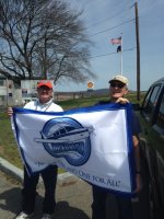
Here I am with Wayne Hansen leaving for the middle of the race and our picnic.
Mike Wightman took the photo.

IMG_1785.JPG
 
James,
All the Marathon flying was done VFR. Boston Approach finds that the cluster of aircraft is so tight that the codes are meaningless. Safety is achieved by putting helicopters and fixed wing on different altitudes (1400FW and 1500HCTRS) and having different direction of flight. There were two Navahos at 13,000' to bounce TV signals from the motorcycles and trucks. Some helicopters were at 950' but I don't know their role. State Police helo was at 1500' and I had communication with them of the CTAF (122.9) about some jurisdictional issues. For the first time I tried using the autopilot to fly me in big circles with the banner tows around the start area. I had limited success but it held my assigned altitude at 1400' fine.
The enjoyment of all this is achieving technical success in a very regulated and potentially dangerous situation. Paul Werbin take note.
Tom Corcoran N5162M
 
Although you get a deduction in points for doing circles. Just kidding.


Sent from my iPhone using Tapatalk
 
Very interesting stuff. The original testing of the ADS-B technology was done in a similar situation at the Atlanta Olympic Games (1998?) and was designed as a collision avoidance system. Were your altitudes correct? Transponder reported altitudes can easily be +/- 200 feet so allowing a 500 ft altitude separation between layers, helos vs Fixed vs Turbo prop etc is the usual starting point. Allowing patterns in specified directions also helps. The New York City Hudson River corridor is a good example that has worked. Similar goal with circling over Statue of Liberty etc.. Or another great example was the Abel Island Fly-in at BACfest 2016.
 
Paul,

Are you related to Cliff Claven? Just wondering!

Alan

Very interesting stuff. The original testing of the ADS-B technology was done in a similar situation at the Atlanta Olympic Games (1998?) and was designed as a collision avoidance system. Were your altitudes correct? Transponder reported altitudes can easily be +/- 200 feet so allowing a 500 ft altitude separation between layers, helos vs Fixed vs Turbo prop etc is the usual starting point. Allowing patterns in specified directions also helps. The New York City Hudson River corridor is a good example that has worked. Similar goal with circling over Statue of Liberty etc.. Or another great example was the Abel Island Fly-in at BACfest 2016.
 
Back
Top